
What is GIS?
What Is GIS?
GIS is a Geographic Information System
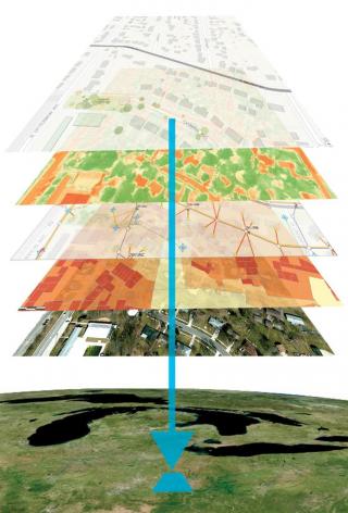
GIS incorporates geographic features with tabular data in order to map, analyze, and assess real-world problems. The word geography indicates a portion of the data is spatial. Features on the earth, such as parcels, cities, roads, and rivers are represented on a map. Coupled with this is tabular data, or attribute data. Attribute data is simply additional information about each of the spatial features. An example would be parcels. The actual location is the spatial data. Additional data includes owner name, mailing address, deeded acres, estimated market value, homestead status, property class, and school district. It is the partnership of these two data types that enables GIS to be such an effective problem solving tool. Data viewed on a map provides an advantage over using spreadsheets or databases because it can reveal patterns, point out problems, and show connections that may not be apparent in tables or text.
What is GIS Used For in Government?
At the most basic level, GIS is used to make maps. Maps are made for electoral districts, emergency services, parcels, public drainage, and roads. It's real power, however, is through spatial analysis to analyze data. Examples of the types of questions GIS might answer are:
- How many acres of tillable land are in Faribault County? A township? A watershed?
- What is the Crop Productivity Index (CPI) for tillable land on a parcel? What is the county average?
- How many acres drain to a public drainage system? Ditch Viewers look at soils, land use, and proximity per 40 acres per parcel when completing a Redetermination of Benefits.
- What affected property owners do I need to notify?
- Does a permit applicant meet the required setbacks or criteria for obtaining a permit?
- What is the address of a new structure?
- Which first responders are dispatched in an emergency? What is the best route to take?
Applications supported by county GIS include addressing, assessment and taxation, elections, dispatching, inspections, land use planning, permitting, property management, and transportation. Maps and spatial analysis quickly make sense of this vast amount of data so it’s easier to use and share with the public. Making data-driven decisions is essential in government. GIS makes it possible!